
Introduction
The alarming rate at which global tree cover is diminishing has spurred a call to action for reforestation and sustainable forest management initiatives. These endeavors are crucial in mitigating the adverse effects of deforestation and combating climate change1. Among the pivotal steps in this effort lies the accurate mapping and analysis of trees, a task that demands technological innovation and precision. Green Mapper, an innovative platform, rises to this challenge by harnessing cutting-edge machine learning techniques, with a particular focus on the YOLOv5 algorithm, to automate the process of tree identification in aerial images2.
At the heart of Green Mapper’s capabilities lies its adept utilization of the YOLOv5 algorithm. This state-of-the-art machine learning model excels in object detection, enabling the platform to swiftly and accurately identify individual trees within aerial imagery. By doing so, Green Mapper empowers conservationists, researchers, and environmentalists with a powerful tool for quantifying tree populations with unprecedented precision. This new found ability not only facilitates a deeper understanding of existing forest ecosystems but also sheds light on areas where tree density is alarmingly low, thus highlighting regions in dire need of reforestation efforts.
One of Green Mapper’s standout features is its capacity to provide recommendations3. This functionality is invaluable in the strategic planning of reforestation projects. By considering factors such as soil type, climate conditions, and local biodiversity, Green Mapper ensures that the chosen tree species are optimally suited for the target environment. This not only enhances the likelihood of successful tree establishment but also fosters the creation of more resilient and sustainable ecosystems in the long run. This work presents an advanced web bot from the ground up by utilizing the capabilities of Node.js and the Puppeteer.js package. The data collecting system is based on this creative bot, which allows us to download high-quality satellite photos from the internet. Every single 640 x 640 pixel photograph painstakingly captures an area of 0.22 square kilometers. Scraping these photographs from many online sources is a complex operation. After being gathered, the photos go through smooth adjustments like cropping and scaling to fit the precise dimensions needed for our project. Following processing, these photos are safely moved to Firebase Storage, guaranteeing data accessibility and integrity. In addition, all of the data is carefully arranged and updated in our MongoDB Atlas database, along with all pertinent metadata. This thorough approach to data collection serves as the cornerstone of our extensive tree-mapping project and guarantees the accuracy and applicability of our information.
Related Work
Employed image analytics and machine learning to automate tree enumeration using satellite data, ensuring precision and efficiency. Traditional manual surveys were slow and error-prone, necessitating automated solutions for accurate tree counting in forest land diversion projects4. Results showed YOLOV5 with 32%, UNET with 81%, and SSD with 24% accuracy. Future work aims to enhance accuracy using high-resolution images and a larger dataset5. Semi-supervised transformer-based framework, TreeFormer, for tree counting in aerial/satellite images utilizing pyramid representation and attention-based modules. TreeFormer outperforms existing methods, offering superior performance with reduced need for labeled data6. This study explores using drones and OpenCV for tree counting in forests. Drones capture aerial images, which are processed by OpenCV algorithms to identify individual trees. While effective for non-linear tree counting, further research is needed on applicability to various forest types and accurate tree species classification7. The researchers tackled automated tree segmentation in forests using multispectral imagery. Their experiments with deep learning architectures and spectral inputs, including vegetation indices, showed improved accuracy. This suggests enhanced forest monitoring potential with remote sensing. In this study, This paper discusses the importance of counting trees for environmental and urban planning purposes. It highlights the limitations of traditional methods and proposes a new method based on deep learning and very high-resolution images. Researchers tackled forest inventory at the single-tree level with deep neural networks and remote sensing imagery. Four tree counting networks derived from classical CNNs were evaluated using a dedicated dataset with high-res images and manually annotated tree locations8. Researchers applied a two-level model (TLM) to forecast above-ground biomass (AGB) in Sweden, utilizing TanDEM-X SAR data from 420 scenes. AGB estimates were derived from forest height and canopy density via TLM inversion with a power law model, with parameters estimated separately for each satellite scene9. Researchers devised a machine-learning method to detect individual trees, evaluate their health, and spot dead or dying trees. They utilized high-resolution aerial multispectral imagery and photogrammetric point cloud data, leveraging features from multiple registered data sources. Evaluating in a Pinus radiata plantation with a Sirex noctilio outbreak, they analyzed the influence of data sources and spatial resolution on performance. Utilizing digital aerial photogrammetric techniques, they created point clouds. Three individual tree crown delineation algorithms were tested, with advanced multiresolution segmentation (AMRS) exhibiting the highest accuracy10.
Materials and Methods
Research Methodology
Our project revolves around a seamlessly integrated system catering to various stakeholders. The user interface features a map-based visualization, providing clear insights into nearby red and green zones. Users can actively engage by participating in drives organized by Non-Governmental Organizations (NGOs), enhancing their involvement through a gamification approach (provide badge and certification in profile) that verifies their contributions. NGOs play a central role in receiving live updates and alerts about local tree balance conditions. Leveraging this real-time data, NGOs plan strategic drives, ensuring efficient allocation of resources. Collaboration among NGOs is encouraged, leading to more successful initiatives. Moreover, NGOs receive tailored suggestions, including suitable types of trees according to regions’ weather conditions and water needs, optimizing their drives for maximum impact. This holistic approach ensures a dynamic and informed environmental conservation effort, fostering active participation, collaboration, and impactful tree-planting initiatives. Fig. 1 shows a bridge between people and NGOs, making it effortless for everyone to contribute to our environment.
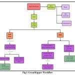 |
Figure 1: GreenMapper Workflow |
When users log in, they’ll see a map showing areas with lots of trees (green zones) and areas that need more trees (red zones). The machine learning-based object detection models is used to count trees accurately, so users know their efforts make a real difference. Users can also find nearby tree-planting events posted by NGOs. When users join these events and contribute, they earn badges and certificates, showcasing their impact. For NGOs, this system offers real-time updates about local tree conditions, empowering them to plan drives strategically. NGOs can even team up for more impactful drives. NGOs can create posts for upcoming tree plantation drives for driving individuals. Our platform fosters collaboration, making sure every tree planted counts. This holistic approach ensures a dynamic environmental conservation effort, collaboration, and impactful tree-planting initiatives. Following are different modules of GreenMapper:
Live Satellite Data Collection
we developed a sophisticated web bot using Node.js and the Puppeteer.js package to automate the collection of live satellite data. This web bot acts as the backbone of our data collection system, allowing us to efficiently download high-quality satellite photos from various online sources. By leveraging the capabilities of Node.js and Puppeteer.js, we were able to create a robust and versatile tool capable of handling complex web interactions and seamlessly retrieving the necessary satellite imagery.
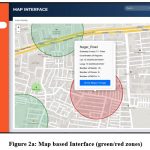 |
Figure 2a: Map based Interface (green/red zones). |
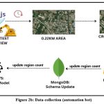 |
Figure 2b: Data-collection (automation bot) |
The web bot operates by navigating through designated websites and systematically identifying and downloading satellite photos of specific geographic regions. Each satellite photo obtained by the web bot captures a standardized area of 0.22 square kilometers, with dimensions of 640 x 640 pixels. The collected satellite images serve as the foundation of our extensive tree-mapping project, providing crucial data for tree identification, counting, and analysis. By employing a systematic and thorough approach to data collection, we guarantee the accuracy and applicability of the information used in our project.
YOLOv5 Model Configuration and Operation
For tree detection and counting, an advanced object detection algorithms and machine learning model i.e. YOLOV5, trained on the multispectral satellite imagery.
Input Data Preparation
Resize and preprocess the satellite images to match the model’s input specifications ensure consistency in image format, color channels, and normalization. To label and annotate data, MakeSense AI tool is used where each tree within the images is marked manually. This typically involved drawing bounding boxes around individual trees, with meticulous attention to labeling accuracy.
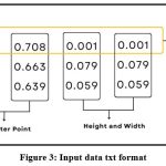 |
Figure 3: Input data txt format. |
Data Split
Following data annotation, we divided our dataset into two distinct segments: one for training and the other for testing. An 80-20 split was employed, designating the larger portion for training the model and the smaller for assessing its performance.
YOLOv5 Model Configuration
To accommodate our specific project requirements, we set up the YOLOv5 model, its dependencies, and hyperparameters. A key aspect of this step was tailoring the model architecture, anchor box sizes, and other parameters to our tree counting task. The annotated datais organised in line with YOLOv5’s directory structure.
Training
The process involves customizing a YAML configuration file to incorporate pretrained weights, dataset paths, and the number of annotated classes. With this configuration, model training begins, offering flexibility to adjust training epochs and batch size as needed. Post-training, the resulting model weights are saved, and comprehensive documentation is retained for future reference.
Model Evaluation
Following training, we rigorously assessed the model’s performance using the testing dataset. Metrics such as precision, recall, and F1-score were employed to gauge the model’s accuracy and generalization capabilities.
Red/Green Zone Visualization
We designed and developed a user-friendly BioMap using Geographic Information System (GIS) tools such as leaflet.js. The primary goal of the BioMap is to provide an intuitive and interactive platform for visualizing environmental data, particularly focusing on identifying areas with varying levels of tree density.
By integrating the BioMap with our tree counting capabilities, users can gain valuable insights into the distribution of vegetation within a given area. The visual representation provided by the BioMap allows users to identify areas with significant tree cover, as well as areas that may require targeted conservation efforts. This comprehensive approach to environmental monitoring empowers stakeholders to make informed decisions and take proactive steps towards preserving and enhancing our natural ecosystems.
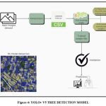 |
Figure 4: YOLOv V5 TREE DETECTION MODEL |
Gamification Approach
To engage users effectively, a gamification part is developed that enabled users to access the maps, contribute to tree counting, and validate existing data. Gamification elements, such as points, badges, and leaderboards, were integrated into the platform to incentivize user participation, making the process both enjoyable and productive as shown in fig. 5.
By actively participating in the project and completing different activities, users can earn different badges that represent their contributions and accomplishments. Users can proudly display the badges they have earned on their profiles. This credential is a great asset for any future ambitions, schooling, or professional chances, in addition to being a testimonial to their dedication. This gamification approach amplifies the impact of joint efforts for a healthier, greener world by rewarding active involvement and transforming each user into a respected advocate for change.
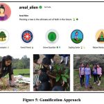 |
Figure 5: Gamification Approach |
Collaboration with local NGOs was a vital aspect of our research. The tree count data and green/red zone maps are shared with these organizations, facilitating data-driven suggestions for plantation zones within identified red areas. A feedback mechanism was established for users and NGOs to communicate, allowing for ongoing refinement and validation of suggested plantation zones. Community engagement was achieved by organizing tree-planting events in partnership with local NGOs, fostering a sense of ownership and participation among the local population. To track the progress of tree planting initiatives, a monitoring system was established to assess the growth of newly planted trees, ensuring that the reforestation efforts were making a meaningful impact on the environment.
Experimental Results
The YOLOv5 architecture-based tree detection technique was used on satellite images, and trees were successfully identified. CNN serves as the backbone network for YOLOv5. A modified Darknet neural network called CSPDarknet53 is part of the design and is used to extract features from input photos. In addition, YOLOv5 has a detection head that predicts bounding boxes, class probabilities, and object confidence scores. To make these predictions, it employs a collection of anchor boxes and convolutional layers. YOLOv5 is capable of effectively identifying trees of different sizes in extensive satellite images. It is ideal for detection due to its speed, effectiveness, and precision. SVM classifiers, on the other hand, struggle with complex background clutter, and RCNN-based methods, with their multi-stage processing, require a lot of processing power and are slower. Because of its single-stage architecture, versatility, and real-time processing, YOLOv5 is the recommended method for tree detection in this specific application because it offers both speed and accuracy. Figure 6 illustrates the structure of the YOLOv5-based satellite image tree detection algorithm.
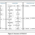 |
Figure 6: Structure of YOLOv5 |
Following a successful training session, the recognized trees appear on the screen. Fig. 6 illustrates the tree detection using YOLOv5 mode. The figure illustrates the presence of the recognized trees and displays their distribution throughout the image. Compared to RCNN and SVM Classifier, the proposed approach was able to detect trees with a high degree of accuracy.
Evaluation and Validation
A confusion matrix in tree detection using the YOLOv5 model from satellite images provides a quantitative assessment of the model’s performance. It helps evaluate the number of true positives (correct tree detections), true negatives (correct non-tree classifications), false positives (non-tree objects falsely detected as trees), and false negatives (missed tree detections). This matrix is crucial for assessing the model’s accuracy, precision, recall, and improvement of the tree detection algorithm. Fig 7 shows the confusion matrix of the proposed model.
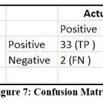 |
Figure 7: Confusion Matrix. |
To confirm the network’s efficacy, we employ a variety of metrics, such as mean average precision (mAP), recall, and precision. When dealing with a classification challenge, samples can be categorized as true positives (TP), false positives (FP), true negatives (TN), or false negatives (FN) based on how the neural network predictions are combined. The formulas for the precision and recall are shown below respectively.
The MAP is the average of the detection precision for all categories and is calculated
where j ( P, R ) is the average precision function, which is calculated using the current class number k. The precision rate P with the recall rate R forms the P‐R area under the curve. n is the total number of classes to detect, and k is the current class.
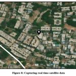 |
Figure 8: Capturing real time satellite data |
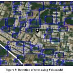 |
Figure 9: Detection of trees using Yolo model |
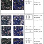 |
Table 1: Experimental Results |
Avg Accuracy: 8865
Avg Precision: 9761
Avg Recall: 8954
The average accuracy, a metric calculated from the test image outputs, serves as a pivotal indicator of the model’s overall predictive performance. This measure, derived from the ratio of accurately predicted instances, provides a quantitative assessment of the model’s efficacy on the test dataset. It stands as a key benchmark, shedding light on the model’s performance and its ability to make accurate predictions.
Table 2: YOLOv5 Evaluation Results
|
Model |
map@0.5 |
Precision |
Recall |
|
YOLOv5 |
0.8865 |
0.9761 |
0.8954 |
Discussion
The results of our study demonstrate the significant impact of GreenMapper in advancing tree mapping and analysis for environmental conservation. By leveraging the YOLOv5 algorithm, the platform achieves precise tree identification and quantification in aerial imagery, facilitating strategic resource allocation and sustainable forest management. Our approach stands out for its automation, efficiency, and accuracy compared to traditional methods and existing technologies.
Comparing with previous research, our project introduces a novel and highly effective approach to tree detection from satellite images. While existing methods have strengths, such as deep learning architectures for tree segmentation or tree counting using remote sensing imagery, our approach offers superior efficiency and adaptability. The YOLOv5-based model eliminates the need for manual feature engineering and preprocessing, streamlining the process and enhancing overall performance.
Conclusion
GreenMapper represents a significant advancement in tree mapping and analysis, offering accurate identification and species recommendations for effective environmental conservation efforts. Its collaborative approach with NGOs enhances the efficiency and impact of tree-planting initiatives, contributing to sustainable forest management worldwide. Moving forward, continued development and integration of new technologies will further enhance GreenMapper’s capabilities, allowing for even more precise and impactful environmental conservation efforts. However, it’s important to acknowledge the limitations of the platform, such as potential biases in data collection and analysis. Addressing these limitations through ongoing research and refinement will be crucial for maximizing the platform’s effectiveness in safeguarding our planet’s natural resources.
Acknowledgement
We extend our heartfelt thanks to everyone who played a role in developing Green Mapper, our innovative platform for AI-driven tree mapping and analysis. A special appreciation goes to Noveracion Global for their generous support. We also recognize the outstanding performance of the YOLOv5 algorithm in tree detection. Green Mapper’s achievements are a result of the dedicated efforts of our key collaborators (NGOs, institutions, etc.). Without their tireless work, this project wouldn’t have been possible. This research is in line with the objectives of the Ministry of Environment, Forest, and Climate Change, empowering citizens and NGOs for nationwide tree-planting initiatives.
Funding Sources
As a software project, GreenMapper relies heavily on open-source resources and contributions from the community. Our primary funding source stems from leveraging freely available tools, libraries, and frameworks, such as YOLOv5 for advanced object detection and Puppeteer.js for web scraping within the Node.js environment. By utilizing these open-source solutions, we’ve effectively minimized costs while achieving significant progress in GreenMapper’s development. This approach not only aligns with our commitment to transparency and collaboration but also ensures that our project remains accessible and adaptable for future endeavours. We are grateful for the vibrant open-source ecosystem that has enabled us to bring GreenMapper to fruition.
Conflict of Interest
There is no conflict of interest associated with the development of GreenMapper. The project has been solely developed through our independent research efforts, without any external influence or vested interests. Our team has meticulously conducted the research, design, and implementation phases, ensuring the integrity and impartiality of the platform. We are committed to upholding ethical standards and transparency throughout the development process, prioritizing the advancement of environmental conservation initiatives above any personal or organizational agendas. Our dedication to unbiased innovation underscores our commitment to serving the greater good and fostering positive impact within the environmental conservation community.
Data Availability Statement
We have developed our own custom bot using the Puppeteer.js Node.js framework to continuously gather live satellite data. This bespoke solution ensures a steady stream of updated information, allowing us to maintain the relevance and accuracy of our dataset. The availability of data for this project is robust, thanks to our proactive approach in creating and managing our data collection system.
Ethics Statement
This research did not involve human participants, animal, subjects, or any material that requires ethical approval.
Informed Consent Statement
As part of our commitment to ethical research practices, all participants involved in data collection for this project provided informed consent. Prior to their engagement, individuals were thoroughly informed about the purpose, procedures, and potential risks and benefits associated with their participation. They were assured of their anonymity and confidentiality, with their data used solely for research purposes. Participants were given the opportunity to ask questions and clarify any concerns before consenting to their involvement in the study. Their voluntary participation underscores their understanding and agreement with the terms outlined, ensuring adherence to ethical standards throughout the research process.
Authors’ Contribution
Author 1: Provided guidance in conceptualizing the project, defining its objectives, and structuring the overall research framework to ensure environmental sustainability.
Author 2: Leveraged expertise in technology as the CEO of Noveracion Global Pvt Ltd to offer insights into the technical aspects, including AI and ML algorithms, essential for satellite tree detection.
Author 3: Contributed to data cleaning, implementing ML models for maximum accuracy, and played a crucial role in project execution and testing, her keen insight was instrumental in identifying the project’s potential
Author 4: Initiated the project idea, developed the web scraping bot for satellite data collection (puppeteer.js, NodeJS), and designed the MongoDB schema with a focus on spatial grid and geolocation.
Author 5: Developed the user-friendly front-end interface, conceived ideas for user badges, and facilitated community engagement through NGO posting drives.
Author 6: Conducted in-depth algorithmic research to devise methodologies applicable to satellite data detection, contributing significantly to the project’s technical aspects.
References
- Ulku I., Akagündüz E. Deep Semantic Segmentation of Trees Using Multispectral Images IEEE Journal of Selected Topics in Applied Earth Observations and Remote Sensing. 2022;15.
CrossRef - Sun Y., Li Z., He H., Guo L., Zhang X., Xin Q. Counting Trees in a Subtropical Mega City using the Instance Segmentation Method International Journal of Applied Earth Observation and Geoinformation. 2022;106.
CrossRef - Windrim L., Carnegie A., Webster M., Bryson M. Tree Detection and Health Monitoring in Multispectral Aerial Imagery and Photogrammetric Pointclouds Using Machine Learning IEEE Journal of Selected Topics in Applied Earth Observations and Remote Sensing. 2020;13.
CrossRef - Dukale.D., Agale.S., Kalunge.S., Nikam.P. Application of Image Analytics for Tree Enumeration and Diversion of Forest Land International Journal for Multidisciplinary Research. 2024;6.
CrossRef - Hani.U.E., Munir.S., Younis.S., Saeed.T., Younis.H. Automatic Tree Counting from Satellite Imagery Using YOLO V5, SSD and UNET Models: A case study of a campus in Islamabad, Pakistan IEEE Xplore.
CrossRef
- Kumar.P.G., Harshini.V., NithyaKalyani.S., Sneha.R. Tree Profiling and Data Analysis of Forest Canopy Cover Using Aerial Images IEEE Xplore.
CrossRef
- Amirkolaee.H.A., Shi.M., Mulligan.M. TreeFormer: A Semi-Supervised Transformer-Based Framework for Tree Counting From a Single High-Resolution Image IEEE Transactions on Geoscience and Remote Sensing. 2023;61.
CrossRef - Yao L., Liu T., Qin j., Lu N., Zhou C. Tree Counting with High Spatial-Resolution Satellite Imagery based on Deep Neural Networks Ecological Indicators. 2021;125.
CrossRef - Persson H., Soja M. National Forest Biomass Mapping Using the Two-Level Model in Learning IEEE Journal of Selected Topics in Applied Earth Observations and Remote Sensing. 2020;13.
CrossRef - Xua Z., Shena X., Caoa L., Coopsb N., Goodbodyb T, Zhongc T., Zhaoc W., Sunc Q., Bac S., Zhang Z., Wua X. Tree Species Classification using UAS-Based Digital Aerial Photogrammetry Point Clouds and Multispectral Imageries in Subtropical Natural Forests International Journal of Applied Earth Observation and Geoinformation. 2020;92.
CrossRef